
One might think that by now we would understand pretty well how the Grand Canyon formed. We don’t.
Central to the problems of how and when the current Grand Canyon formed is the Muddy Creek Formation, a bunch of freshwater lake sediments of late Miocene/early Pliocene age (5-6 my). These formed in a lake to the west of the Grand Wash Cliffs that form the western edge of the Grand Canyon and the Colorado Plateau.
The problem is that the Colorado River has cut through these sediments, limiting the age of the formation current river course (and the Grand Canyon) to sometime more recent.
A very good synopsis of the problem is presented by Joel Peterson (2008)
Click to access i1052-5173-18-3-4.pdf

A graphic from this paper above shows the distribution of the Muddy Creek Formation in relation to the “W” of the Grand Canyon. It also shows some ideas for the direction of Colorado River flow prior to the present. The Peterson paper rules out the “C” arrow because the Muddy Creek sediments match the Virgin River and not the Colorado River. An earlier “A” direction has been ruled out, leaving only “B”, the current course.
How do we resolve the current course with the Muddy Creek Formation? Where was the water going before 6 million years ago if not into the Muddy Creek Lake?
Humans are not the first Dam builders on the Colorado River. The infamous Lava Falls Rapid is formed by a lava dam. The latest work on Grand Canyon lava dams Crow et al (2015) identifies 17 lava dams within the last million years.
Click to access d8c55fbdfead6d612a6a0c2cf94ec07bde3e.pdf
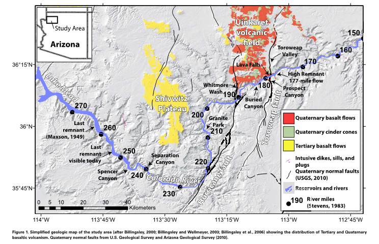
The graphic above from Crow et al shows these extensive flows beginning at river mile 177.
These dams filled the river channel for over a hundred miles in some cases. Volcanic remnants can be seen 1000 feet above the river. The effect of all this damming would be to slow the river and cause it to drop its sediment, keeping it out of Muddy Creek Lake even if significant Colorado River water leaked in to Muddy Creek lake through karst tunnels and around the dams. Karst tunnels dump impressive amounts of water from the canyon walls today at Thunder River, Tapeats Creek, and Vasey’s Paradise.
This scenario keeps the Colorado River flowing in the only plausible direction, allows the greater lateral erosion (and apparent geomorphic age) in the western Grand Canyon to take place above the lava lakes, fills Muddy Creek Lake with Colorado River water but not sediment, and allows the cutting of Muddy Creek sediments within the last few hundred thousand years after dam breaches. The only fly on this lovely picture is the lack of evidence for these sediments upstream.
We have a modern analogue for the fate of river sediments behind dams: the Lake Mead deposits exposed by the fall in lake level in the last few years. River runners have a great perspective on how fast this erosion takes place. The stuff is constantly falling in the river, and is often a dusty nuisance. We noticed significant erosion of these unstable sediments in a single year. One can easily imagine the whole lot washed away in a decade. Perhaps we should be looking for bathtub rings rather than sediments upstream.


