Here at the gymnosperm/trunkmonkey research institute we have been spending a lot of time sorting rocks. It is utter drudgery and we would have quit a long time ago had the results not been so intriguing. Basically, we belatedly discovered various USGS databases with shape files for rock units with coordinates anchored in space. Unfortunately, this data is not sorted in the fourth dimension, time. So we have been sorting the units by time. This might seem easy, but we are dealing in the case of the western United States with a covey of State Geologists with different conceptions and styles. We are also dealing with rock units that are utterly unimpressed with our preconceptions. They exploit old weaknesses and extend through time and through whatever paleontological, statuary, or geological boundaries we have contrived.
Previously, we explored the compiled geological evolution of the western United States. Everything has a derivative. There are several circular granite features on earth that make this interesting. What if you look at the periods individually?
Couple things worth sharing:
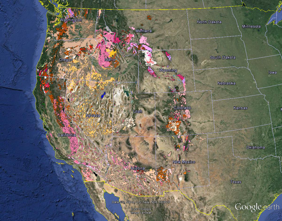
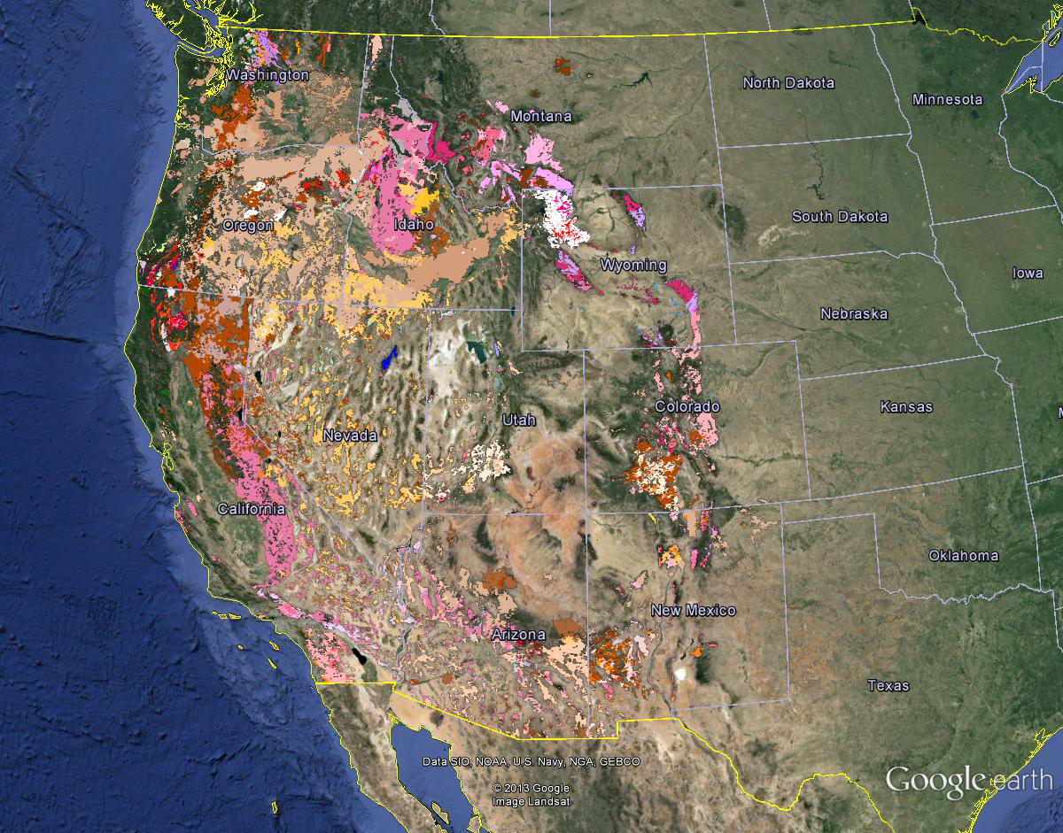
These are the Cretaceous rocks of the western US. What is surprising here is the band of granites extending from the “Salinian” I had previously attributed to strike slip, across Nevada and to the Idaho batholith. This represents a regression from the late Paleozoic/early Mesozoic pattern of igneous activity through the Klamath’s, Blues, And Wallowa’s.
Had to check a few times, but the Pleistocene, the reputed time of uplift of the Sierra Nevada and the Great Basin, shows little igneous activity south of those basalt puddles north of the Mendocino Fracture Zone? There are exceptions, the Konocti volcanics in the California Coast Ranges, the Sutter Buttes, the Long Valley Caldera. A few basalts along the Wasatch Front and along the Rio Grande Rift in New Mexico…
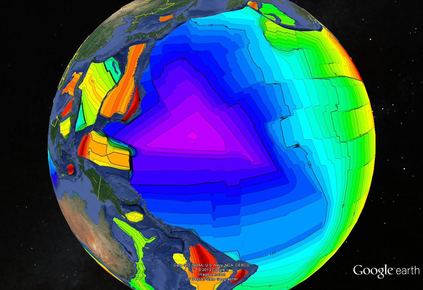
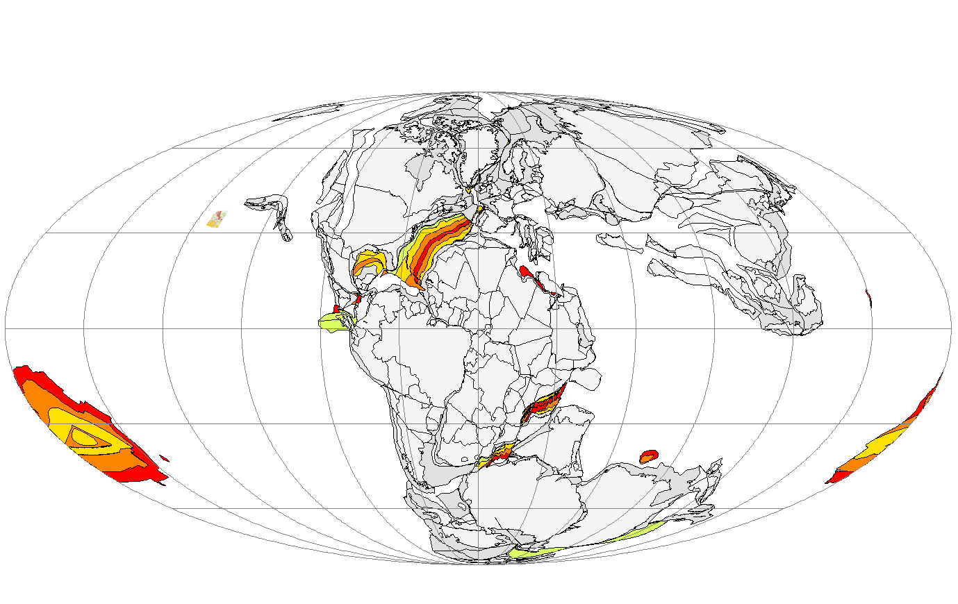
The triangle is formed by lines of equal age in the ocean floor derived from bands of alternating magnetism as the earth’s pole flipped. It is one of the great mysteries discussed previously. The ocean floor gets progressively older from all three sides towards a small triangle in the middle. If this were the remains a hot spot where ocean floor was emerging and spreading out, it would be progressively younger toward the center.
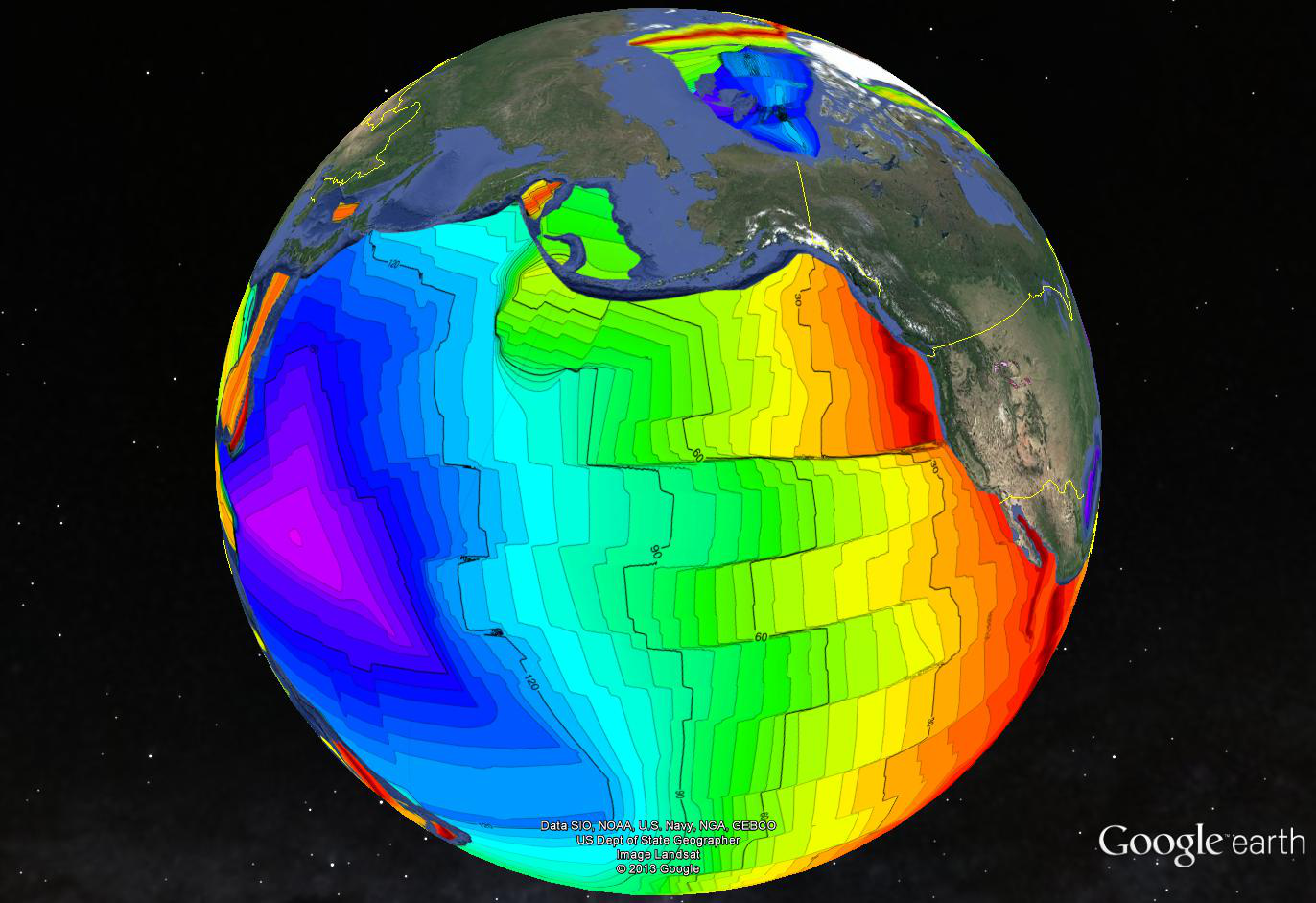
How could such a feature form? One possibility is that it is the signature of a sink hole, the tectonic opposite of a hot spot. Another possibility is that the tiny center triangle marks a place where three ridges arose at the same time and spread away. Interesting regarding either possibility is that the signature of the Mendocino Fracture Zone (visible extending to the right all the way to the Juan De Fuca Ridge) telegraphs back to the 170mya chron. The Murray and Molokai Fracture Zones further south seem to bottom out at 150mya.
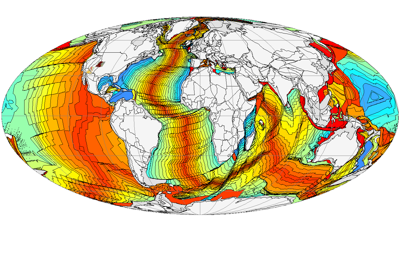
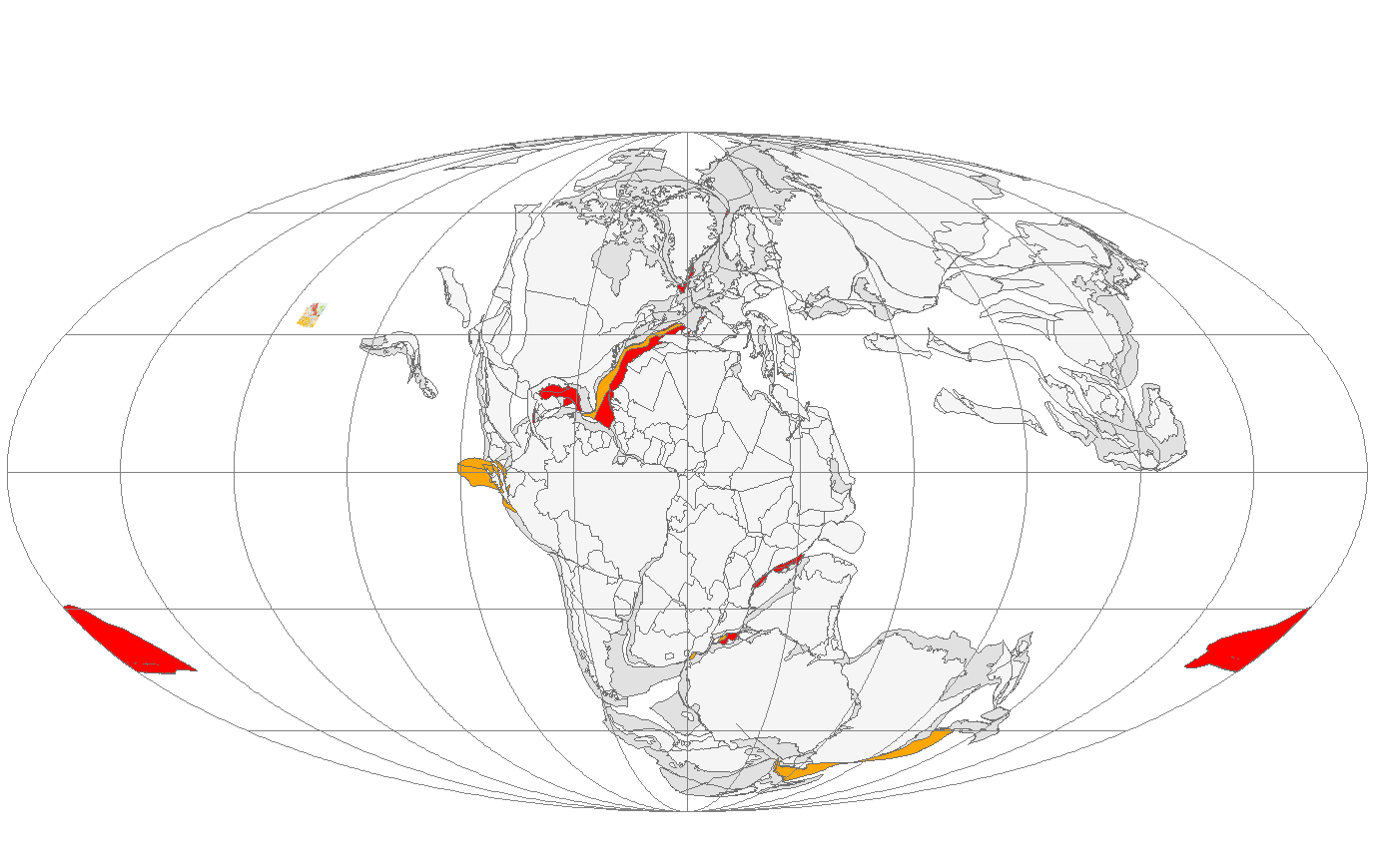
Here is an image of a map by Christopher Scotese showing the isochrons for the whole world. The age is RGB, with red the youngest and blue the oldest. You can see that ocean floor emerges at the spreading ridges and spreads in both directions. Bilateral spreading.
Here is Scotese at the beginning of ocean floor time 180mya. There is actually some 250mya ocean floor north and east of Africa discussed previously, but it is of little importance here. Contemplate the sheer mass of ocean floor showen white here that all gets subducted one way or another to make room for what we see today.
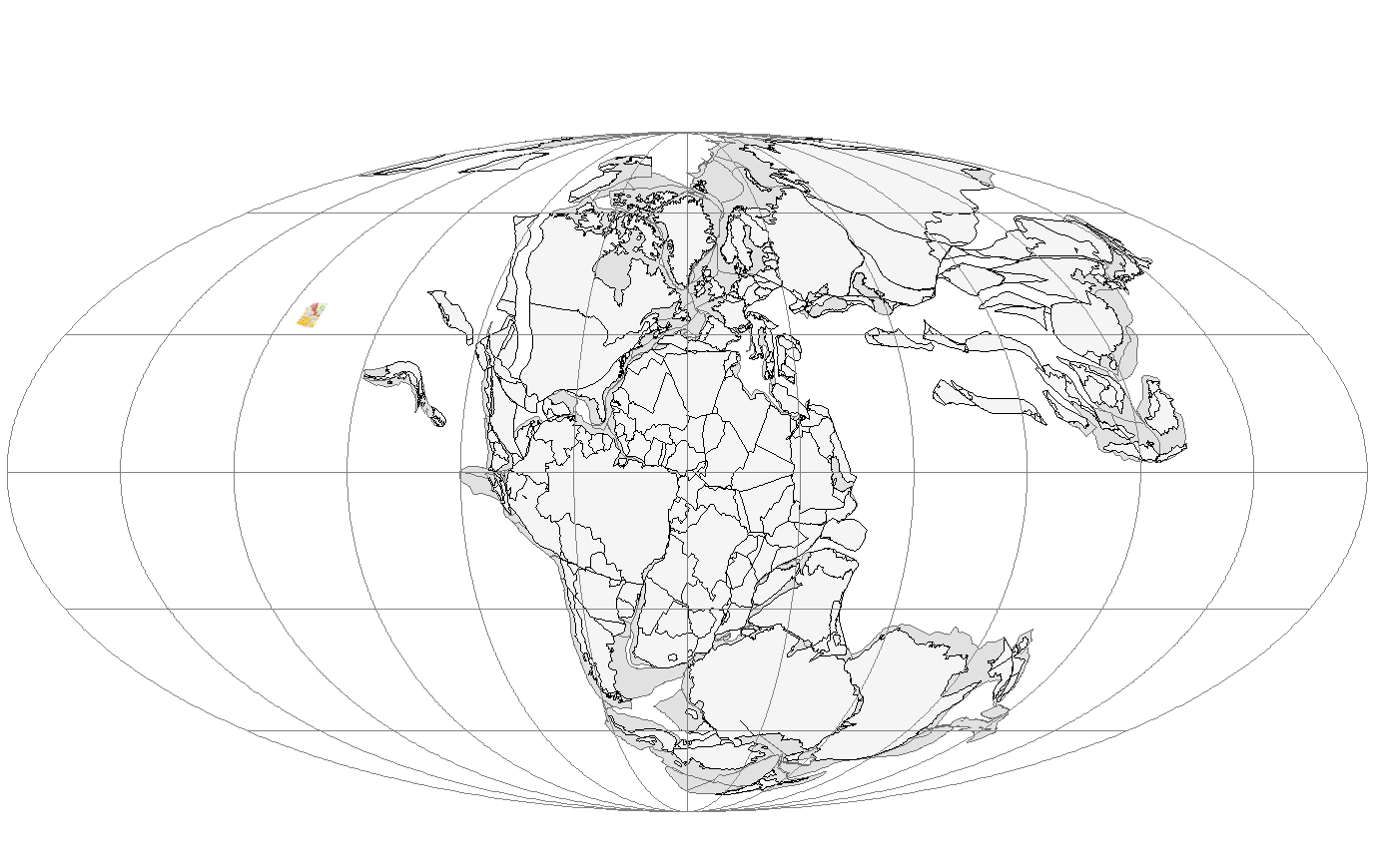
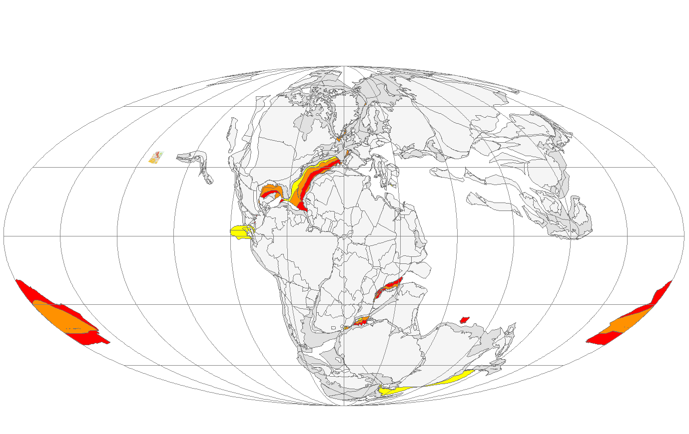
Unfortunately the Pacific Triangle gets divided between the lower right and left in this projection, but there it is, starting out rather too large at 170mya, but infilling properly with older material at 160 and 150mya. What Scotese is saying here is that he believes it was ridges propagating from the tiny triangle. Notice that the Triangle is the only place ocean floor is formed away from a continent, and that continental rifting seems unilateral (one sided). We see no bilateral spreading before 150mya.
Interesting. If this is correct, the Juan de Fuca Ridge is a remnant of the original troika and its signature can be traced back to the 170mya isochron.
The original sin, secondary, tertiary, quaternary sins.
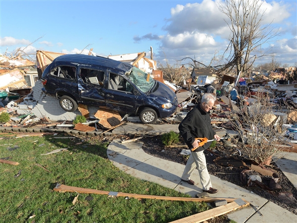
Hurricanes, tornadoes are upon us. Quick! Find a witch to burn.
Well, at least he saved the weed eater.
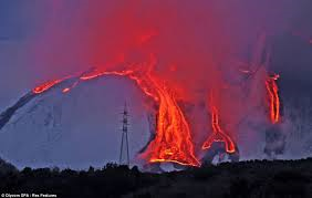
Not to minimize the tragedies, just the sensationalism. Nobody wants their house trashed and people killed. Mt. Etna is erupting too. Do you think Carbon dioxide caused that?
The Carbon in our bones spewed from volcanoes. Our DNA is a spinning vortex. Cataclysm is our heritage, not our fault.
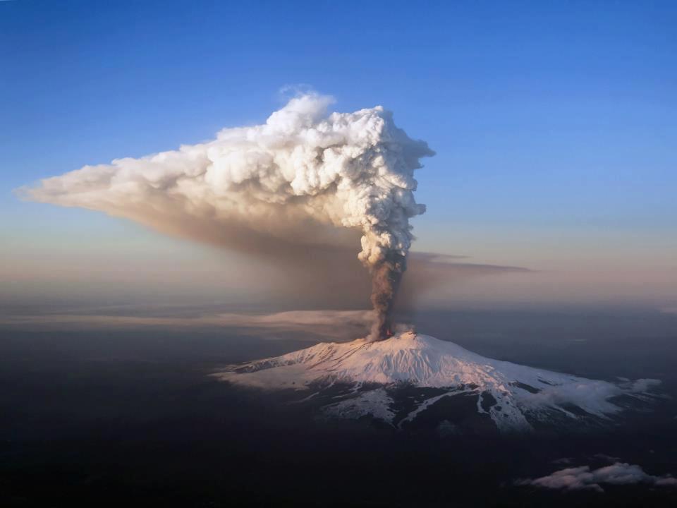
When you look at the big picture it Mt Etna looks like this:
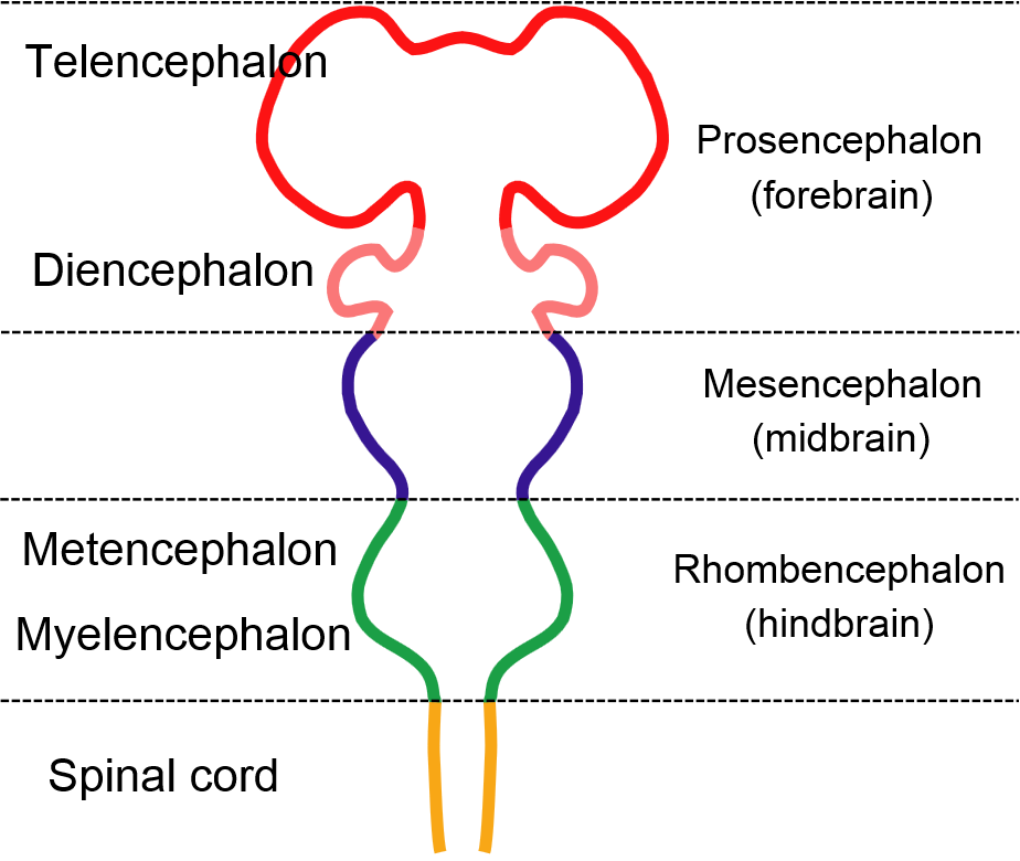
Our brains are layered in the same way sedimentary rocks are. In our lower brains lie the basic functions: breathe, eat and drink, thermoregulate, and reproduce. These are Archean functions we share with all living things. All beautiful, non-predictive analogies can be drawn too hard, but we suggest that the next layer might be Ediacaran functions in the mid brain: hard shell defense and fight or flight?
You can see where this is going, so we take a leap and call the upper brain a Pleistocene function whose properties are metaphor, art, and language.
There may be some rough correspondence to Sigmund Freud‘s conceptions of Id (let’s party), Ego (it’s all about me baby, I’m outta here), and Superego (what will the neighbors think?)
The human brain is way more complex than this, of course, with cross wiring between hemispheres and multiple redundancy everywhere. Yet the stratigraphic architecture sheds some light on original sin. We are constantly “conflicted” between the socially conscious communicating and cooperating forebrain and the lower layers whose impulses would wreak havoc on these niceties.
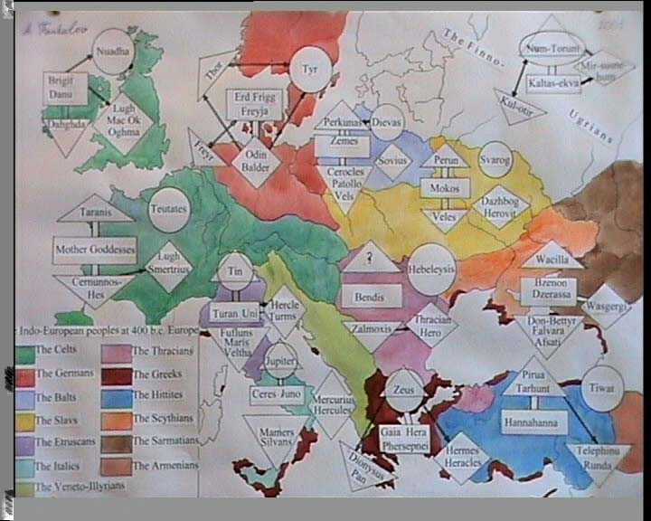
There is an Indo-European pantheon of gods embedded in the language and culture of these yeomen whose pastoral, agricultural business model was so successful they spread from central Europe east to the Indus Valley and Iran and west to England and Scandinavia and south to Egypt and north Africa.
Credit fantalov@lycos.com
The downward pointing geometry represents deities of “earth powers “, which we suggest are metaphor for lower brain and connection to the natural world. Gaia is a Greek version not mentioned above.
Humans are creatures of metaphor and representation. We are creatures of language. We painted cave ceilings, we erected stone monuments, we dug underground cities and filled them with model soldiers.
We are partly of the sky (circles above) and partly of the earth. We feel the separation. This is our original sin, and this is why we live in fear, as our predecessors; of Gaia’s revenge.
Granite is the currency in the construction of continents. Here we will time step through the existing surface expression of granites and related igneous and metamorphic rock in the Western US from the Archean to the present.
Sediments are boring. You don’t want no downstream beer. Geologists love them because they stack nicely and behave in predictable ways, but they clutter up geologic maps so as to obscure the exciting stuff. Here we invoke Vulcan, and Vulcan only.
Before 2.5 billion years ago we have no idea where the continents were located. The Archean is expressed in the western US as currently NW trending granite batholiths in Wyoming and Montana.
Between 2.5 and 1.6 billion years ago we see an extension of granitoids in a current north-south trend into Colorado and the Rio Grande Rift that we now think of as the Rocky Mountains. What is very strange is that we also see development on a different trend in Arizona south-west of the Colorado Plateau. Perhaps the Colorado Plateau was a separate craton then and differential rotation created the discordant trends.
From 1.6 to a billion years ago we see further development along the discordant trends with new plutons in Colorado and extension to very near the current coast in the San Gabriel Mountains. There is also activity in Montana and Idaho roughly parallel to the Arizona/California trend.
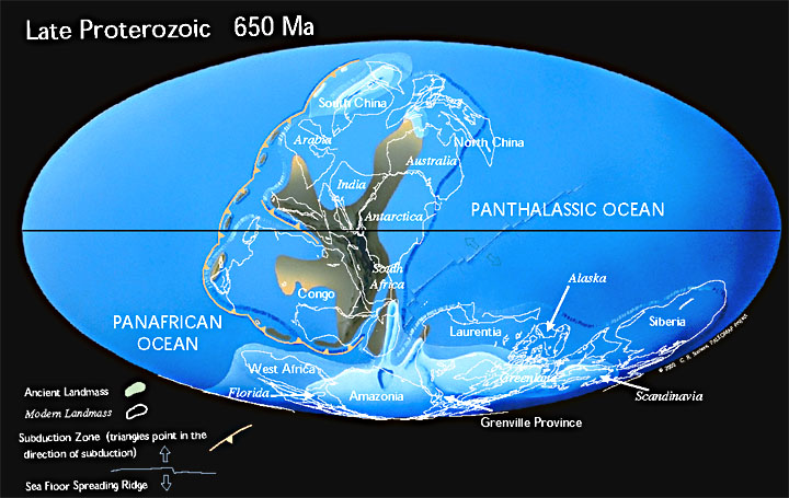
The neoproterozoic between a billion years and the Cambrian adds the finishing touches to the Proterozoic mountain building era and ushers in the extremely boring Paleozoic where pretty much nothing happens. We begin to get some idea where the continents may have been.
Christopher Scotese thinks they looked like this, but the magnetic alignments used to create the reconstruction are very uncertain before the Paleozoic. The western US would be Laurentia down there under the ice. Scotese even suggests my Colorado Plateau craton if you look closely.
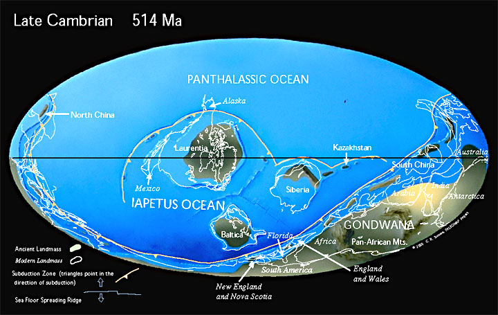
The Cambrian above ushered in the Paleozoic era where not much happened in the western US for a half a billion years.
Mr. Scotese would have us floating idyllically as an island paradise at the equator in a drastic turn of events from 650 mya.
Ron Blakey has it like this. Anyway, for whatever reason, is spite of beginning the role of a castaway sailing into the Panthalassic Ocean it would maintain for most of the Phanerozoic, North America as evidenced by the western US shows very little tectonic activity in the Paleozoic.
Here, jumping ahead a couple hundred million years to the Carboniferous we resort to showing some lowly sediments in the Roberts Mountain Thrust in Nevada out of sheer boredom. The trend of the thrust is unclear it seems to suggest the beginning of the current lineation in Nevada and to follow from activity in the Klamath mountains.
This is about when the collision forming the Appalachians occurred.
We close out the dull Paleozoic with the Permian about 250 mya as the great extinction occurred.
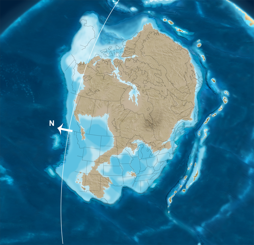
Ron Blakey’s Triassic at 245 mya above. Important changes were brewing. North America was separating to sail off into Panthalassa once again, a voyage that will bring continuous mountain building to the western US from the Mesozoic to the present.
The great extinction at the Permian/Triassic transition was followed by wild fluctuations in Carbon isotopes as life on the planet alternately rebounded and regressed. Volcanos were spewing in a grand arc evident in vegetation today from the southern end of the Sierra Nevada batholith, to the Klamath, and through the Blue and Wallowa Mountains and into Idaho.
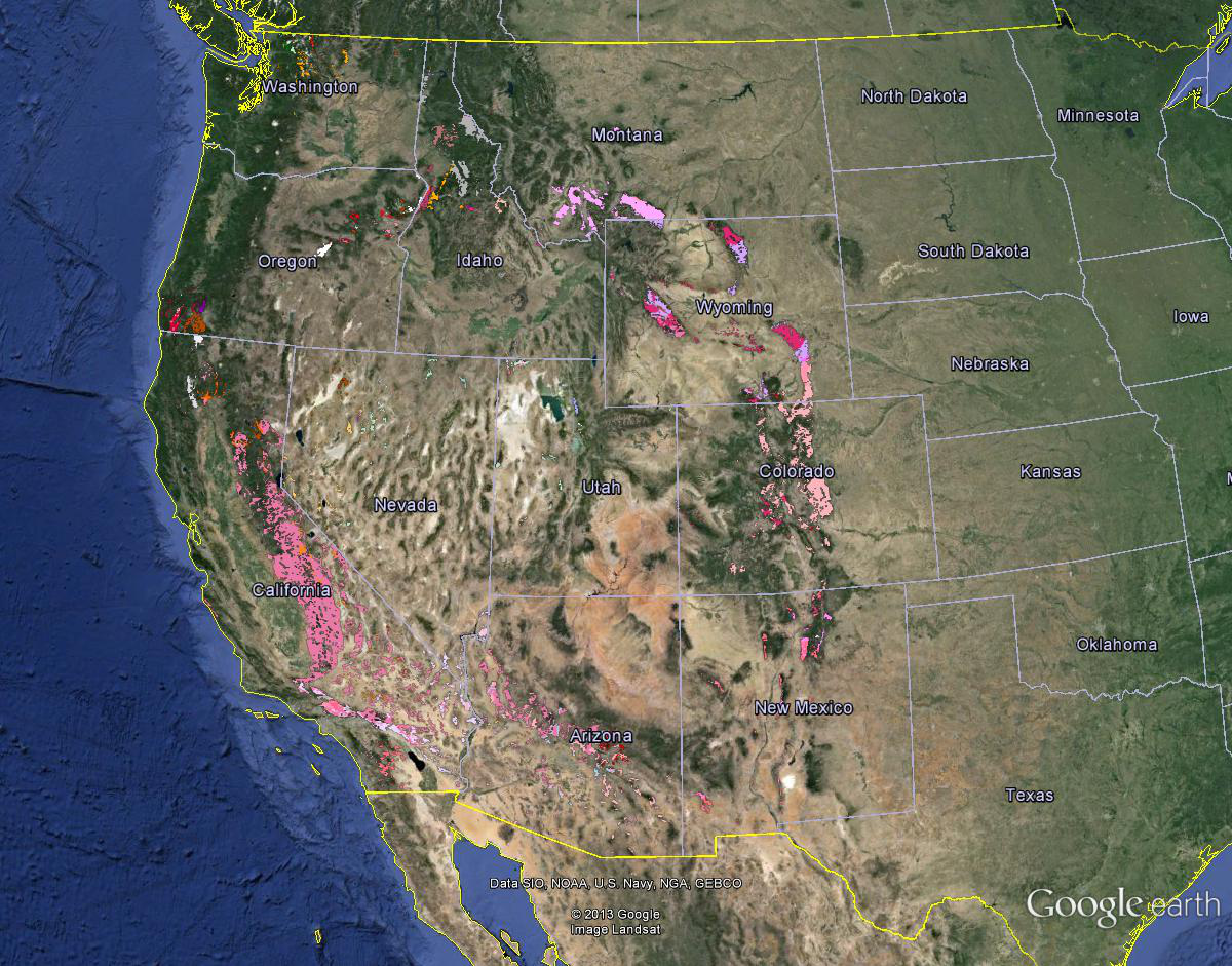
By the end of the Cretaceous 65 mya as the dinosaurs passed, a circle was completed as the Idaho batholith joined the Archean granites. An important volcanic center was forming in northern Washington.
During the Eocene andesitic volcanics began extending northward from the Klamaths and southward from Washington in the line we think of as the Cascades. The Absoroka volcanics formed at Yellowstone.
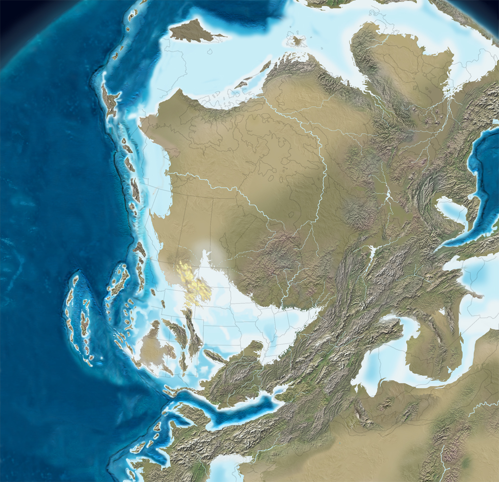
In the Oligocene felsic volcanics swept across the Great Basin in Nevada and Utah and important volcanic activity began in the San Juans of Colorado and in western New Mexico.
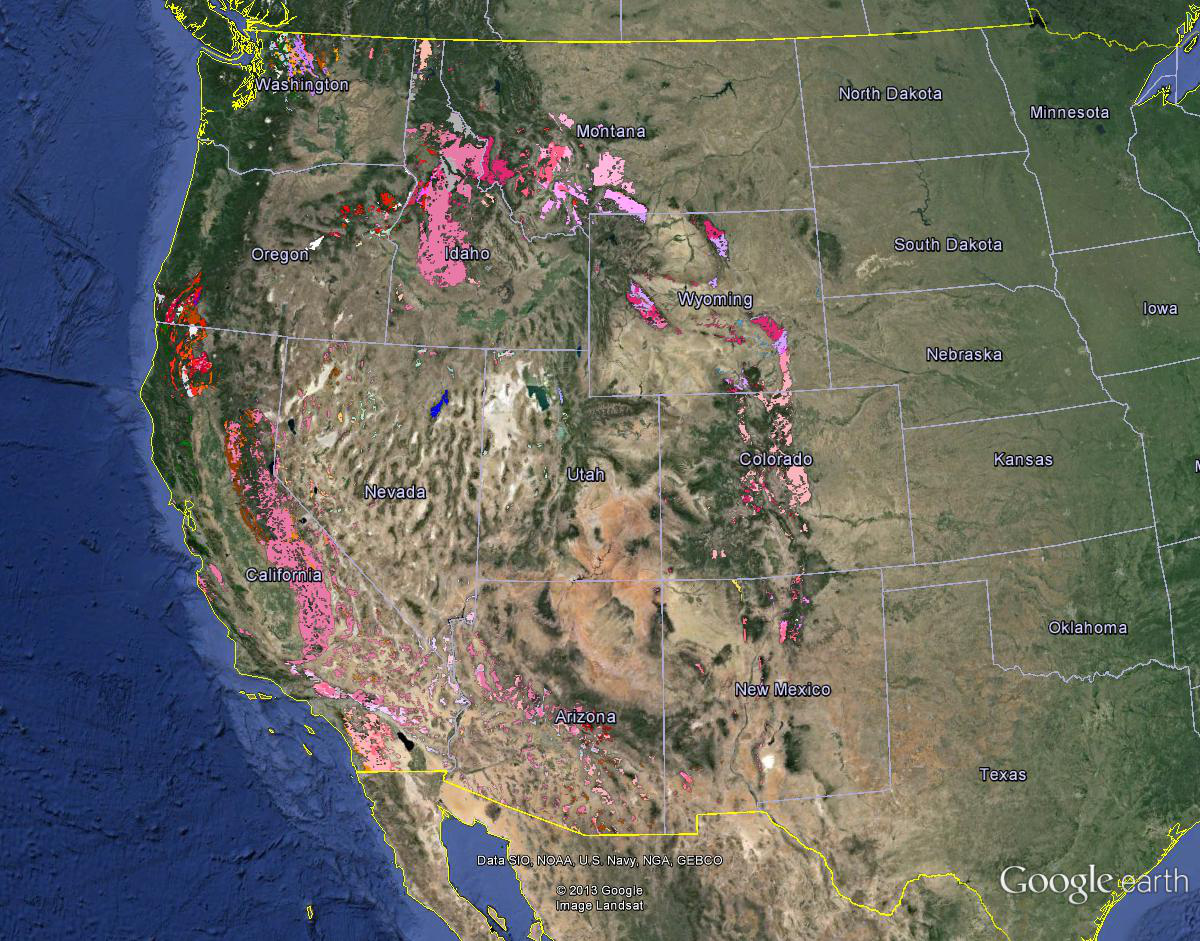
The Miocene saw the impressive spreading of flood basalts. Those things are almost as bad as sediments. There was also an interesting arm of felsic volcanics extending into southern Utah. Note the felsic volcanics beginning to extend up the edges of the Snake River Plain.
We jump to the present as flood basalts basically cover the Pacific Northwest.
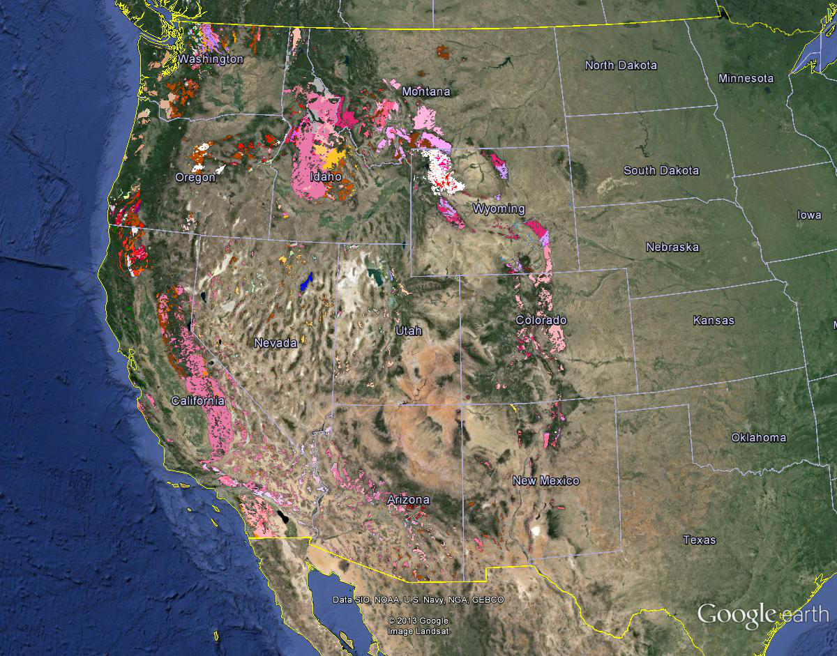
When we follow the granite we see a great concave arc formed during the Proterozoic, an interlude during the Paleozoic, and the completion of a ring of granite with a great convex arc in the Mesozoic. The Cenozoic basically extended the circle to include the Cascades and filled it in with a “bimodal suite” of flood basalt and felsic tuffs.
In the beginning there was a great flash of light, and soon there was the primal proton, Hydrogen, which fused to produce Helium , and so on, within supernovae, to create our pantheon of elements.
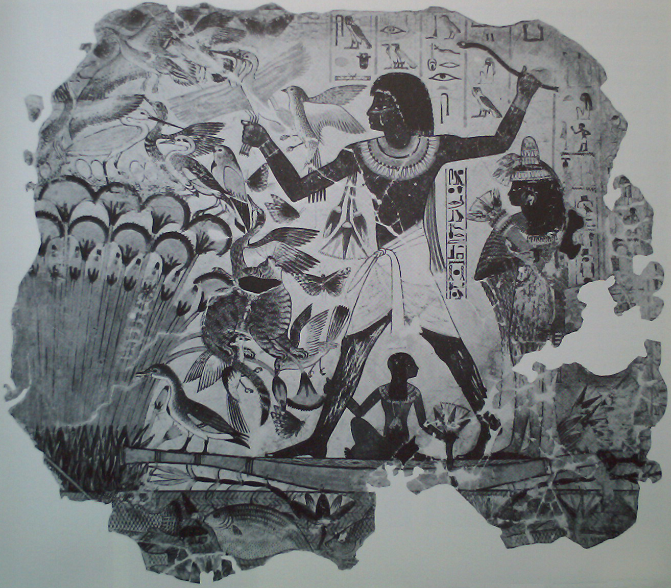
Honestly, we need to muster the honesty to acknowledge that our modern “scientific ” cosmology is no less bizarre and improbable than any that has come before. “In the midst of Nun, Atum released his divine energy to create Shu, who begets the other gods of the pantheon.” So went the cosmology of Heliopolis, inscribed 4500 years ago in Egypt.
Pantheons come and go, and here we are interested in Vulcan, many generations removed. He is the Roman god of fire and volcanoes.
Vulcan speaks to deep seated human awe of fire and the mysterious workings of the underworld. The power of fire is manifest in the Indo-European/Hittite/Celtic forge, where metal can be smelted from rocks to create instruments of power and hegemony.
Yet from the toxic mud and caustic sulfurous fumes, our modern cosmology would have the elements Hydrogen and Oxygen emerge from the deep to create our oceans, the element Carbon to enable life, and Nitrogen to fill the atmosphere.
We would have these elements coalesced from cosmic dust to form our planet until their sheer weight and intrinsic energy cause them to boil through the crust.
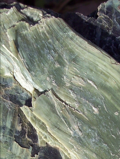
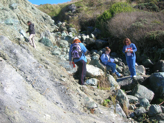
Serpentine is the California State Rock. The effluent of toxic mud volcanos might seem a strange choice for a state rock, but the related higher grade blue and greenschist metamorphism has produced eerily beautiful rocks with sinuous veining from which the name probably derives.
A mud volcano emerged as a small island off the coast of Pakistan last month after the recent earthquake there. The beautiful stones worthy of state rocks are found as clasts entrained in a slurry of highly pressurized hot water and mud formed many tens of kilometers below the surface.
Photo credit Terry Wright. These women are exploring greenschist clasts in a serpentine mud matrix. The “purple dirt” and the serpentine coloration of the clasts derives from chromium and cobalt.
One can find serpentine soils in California by simply gazing for “serpentine barrens” in the hills. The high levels of nickel, cobalt, and chromium and the deficiency of potassium and phosphorus and an unfavorable calcium/magnesium balance make serpentine soils inhospitable to all but grasses and a few specialized flowering plants.
Due to its high pressure hydration and disorganized chemical structure, serpentine is much lighter than the ocean floor basalts from which it is made. Before there was granite and before there were continents there was probably serpentine, bubbling up through fractures at young, hot subduction zones to create land like shallow provinces too buoyant to be forced back into the mantle. Let’s call it primordial subduction.
Serpentine causes magnetic anomalies and can foul up compass readings. Its formation is known to create abiotic methane in the high pressure but relatively low temperature conditions as water is squeezed out of descending hydrated ocean floor at subduction zones. Thomas Gold believed that much of the hydrocarbons we live by were produced by microbes from mineral methane.
With this bag of tricks it is rather like the serpent after all.
Besides the ocean spreading ridges there are several mysterious “hot spots” evident in seamount chains where volatile components of the mantle emerge at a point as a more or less continuous volcano. The most famous of these is the Hawaiian/Emperor seamount chain and the Hawaiian “hot spot”.
The classical notion of the tectonic evolution of North America is that such a hot spot burned its way up the current path of the Columbia River and now resides beneath Yellowstone. Below we will time step through the existing surface rocks to evaluate this notion.
We start in the Paleocene, just after the dinosaurs bought the farm and the great central seaway that had occupied the plains states for fifty million years was pretty well dried out. We see some remnants of this seaway in Paleocene sediments in the plains of Montana and Wyoming. Pretty quiet. Some volcanics and related sediments along the Oregon coast, some volcanics in central Oregon that extend marginally to the Modoc Plateau of California, and the fingers of sediment in an intermontane seaway in central Utah.
Next we go to the Eocene. This is the time of the so called “Laramide” orogeny and we can see volcanics popping up around the Achaean granite plutons in Colorado, the Absaroka field in Yellowstone, and the Mesozoic Idaho Batholith. We also see new granites forming in Montana, Idaho, Nevada, and Utah. Volcanism continues in central Oregon and extends up the coast into Washington. It is worth noting that the Yellowstone volcanic fields were well established in Laramide time.
The Oligocene is notable for a wave of volcanics across the Great Basin. We are still waiting for any indication of a hot spot systematically burning its way to Yellowstone.
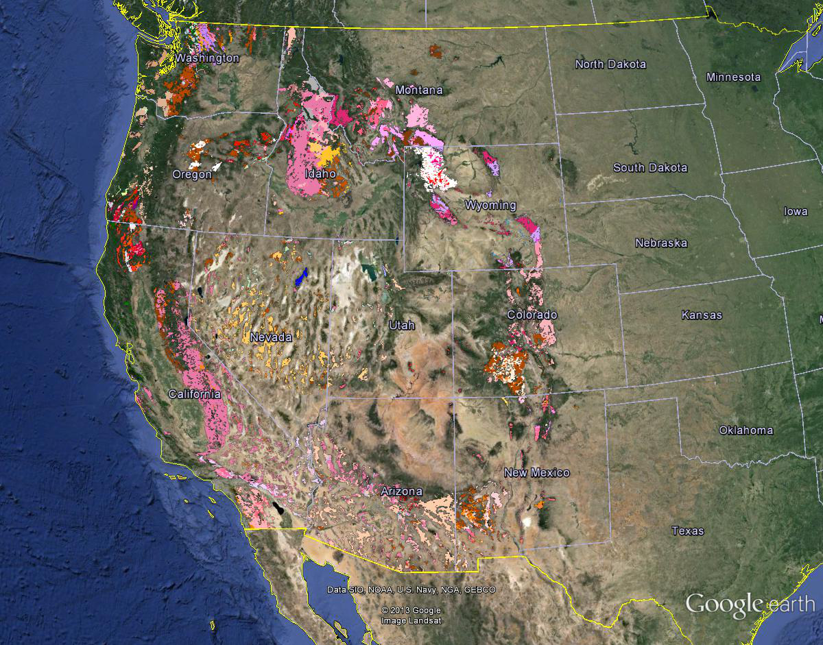
In the Miocene we get some serious action with volcanics covering large areas of California, Nevada, Oregon, Washington, and Idaho. The state geologists could have done a better job coordinating colors of what are obviously continuous units.
The Pliocene shows only a continuation and infill of the Miocene volcanics and valley sedimentation.
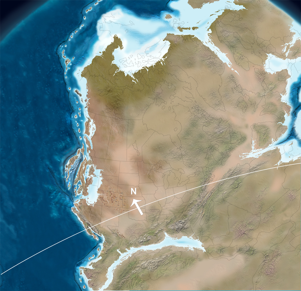
In the Pleistocene we finally get the Columbia River basalts filled in with related volcanics extending to join the Absaroka field in Yellowstone established forty-five million years earlier. The Great Basin is filled with sediments.
The notion of a Yellowstone hot spot has always been generally associated with the ocean spreading ridge that remains offshore northern California, Oregon and Washington. Weak subduction from this ridge is believed to cause the volcanism in the Cascade Range. The evolution of volcanics in the western United States is more consistent with general uplift as the continent passed over the linear mantle upwelling below the ridge than from the focused activity of a “hot spot”.
In five decades of mountaineering in the Sierra Nevada, the wilderness has changed from a wild west dominated by cowboys and pack trains to a highly regulated theme park with lotteries for permits to visit the most desirable locations. With feet in both these worlds we seek to circumvent the regulation, in a sense the opposite of wilderness, yet leave no trace.
Mountain guides call folks possessed with the notion climbing peaks, “pointy heads”. At age 16 such possession led me to run up a boulder chute on the west face of Mount Whitney for my first ascent, gaining a brutal headache. Time and many ascents have rounded my point, but we all have in us a little bit of what drives the many pilgrims to be found flagellating themselves as they stagger up the trail to the top.
We chose to circumnavigate the mountain because it was easier to get a permit, and to avoid until the last exit day the hordes of pilgrims and what they have collectively visited on the landscape. To do this we entered via the North Fork of Lone Pine Creek, an approach that quickly filters out the casual with The Ledges. These are technically easy, if a bit awkward climbing over trees jammed into cracks, but exposure in a couple places forces you to look your own death squarely in the eye.
John Muir used this approach to achieve one of the first few ascents and deemed it, “not for the soft and succulent.”
Eerie clouds over Mount Whitney (right background) were the harbingers of powerful winds promised by forecasts of a coming storm. We carried our packs over the “knapsack” col separating Mounts Whitney and Russell before the storm arrived and descended the glacial cirque leading to Guitar Lake on the west side of the mountain.
An early morning shower left a quarter inch of snow and we had a full day of winter as winds whipped flurries and 15 degree air as the storm reached a crescendo leaving two inches of snow.
Then it was over and the night turned clear and cold. Our shoes crunched through the two inches of snow as we left camp for the climb. We met only one man, the second we had seen since the parking lot at Whitney Portal, on the climb up the west side to Trail Crest. Here we joined the regular pilgrimage and dire warnings from earnest young people of savage winds failed to verify. The weather was on a roll and we reached the summit in weather suitable for a down jacket picnic.
The beautiful light in the solitude of our descent back down the west side to camp, fluoresced the lichens, busy eating rocks, unnoticed on the way up.
We rejoined the pilgrims the next day on the way down to the cars and they were a source of hope and inspiration. They had entered many lotteries to get their chance. The fit young couples brought back memories. The presence or absence of natural tolerance for altitude is evident in body language. We were all pilgrims on the same path now. We had just taken a more circular route to get there.
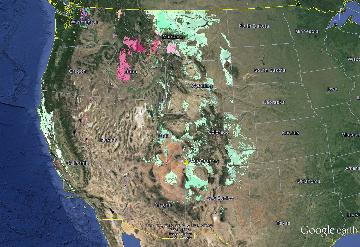
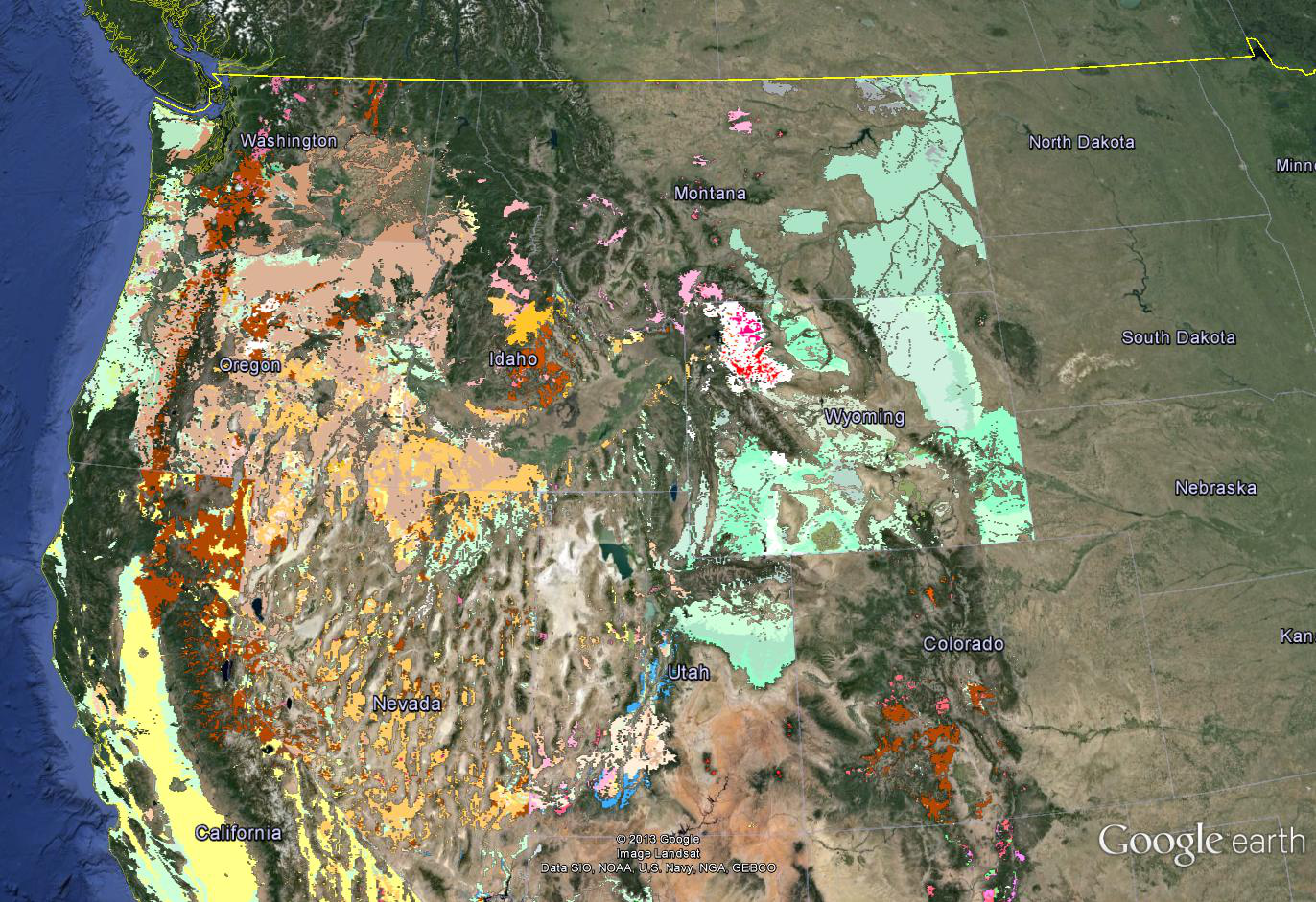
A huge problem with geological maps is that their daunting psychedelic maze of colors makes it very difficult to bear down on specific features. We recently discovered a GIS series of State scale maps from USGS where it is possible to turn on and off individual geological units. This is a quick report on an ongoing effort to bring higher resolution data to bear on the shapes of the continental margin.
The protocol here was to strip the entire Tertiary section from the opaque geology. The result is that the Tertiary becomes a window into the underlying current gravity layer. A late Cretaceous paleogeographic map by Ron Blakeley was then rubbersheeted to match the State of Colorado and aligned at the Four Corners. This was not a satisfying procedure but the result is close enough to show what Ron was thinking. His layer was made transparent to the extent that the gravity and geology are visible and his continental areas read as dark shading.
It is interesting that Ron shows the sierra batholith as a peninsula with an inland sea extending into Nevada behind it. I am going to respectfully disagree about this inland sea based on the lack of Cretaceous marine sediments and the plentitude of granitoid plutonism in the region. Wherever you see granite, something was cooking. Our magenta line attempts to show the western edge of Cretaceous granite.
Ron shows a large inland sea in the central U.S. that is certainly borne out by widespread Cretaceous marine sediments.


![IMG_0306[1]](https://geosciencebigpicture.com/wp-content/uploads/2013/10/img_03061.jpg)
![IMG_0288[2]](https://geosciencebigpicture.com/wp-content/uploads/2013/10/img_02882.jpg)
![101_0469[1]](https://geosciencebigpicture.com/wp-content/uploads/2013/10/101_04691.jpg)
![101_0479[1]](https://geosciencebigpicture.com/wp-content/uploads/2013/10/101_04791.jpg)
![101_0494[1]](https://geosciencebigpicture.com/wp-content/uploads/2013/10/101_04941.jpg)
![101_0510[1]](https://geosciencebigpicture.com/wp-content/uploads/2013/10/101_05101.jpg)


